 |
Waynesville
is conveniently located in the western mountain region of North Carolina, near all the attractions of the Great Smoky Mountains. The town of Waynesville is the county seat of Haywood County, located between Asheville and Sylva near the Blue Ridge Parkway. Balsam is located in Jackson County between Waynesville and Dillsboro within the Nantahala National Forest. Both are easily located via U.S. Highway 23. This is a region proud of its mountain heritage, where visitors are welcomed with open arms and warm Southern hospitality. The Great Smoky Mountains National Park, the Pisgah National Forest and the Harmon Den Wildlife Refuge occupy about 40 percent of the area surrounding Waynesville/Balsam. This translates into abundant outdoor recreational opportunities such as snow skiing, hiking, mountain biking, horseback riding, whitewater rafting, fishing, boating and golf. You are just minutes from the Biltmore House in Asheville, the ski resorts of Maggie Valley, the Cherokee Indian Reservation and Casino, gem mining and the Great Smoky Mountain Railroad. There are numerous shopping options in Waynesville/Balsam, including local arts and crafts and antique shops. Lodging can be anything from a rustic mountain cottage or cabin, cozy bed & breakfast or a gorgeous mountaintop vacation home. Come enjoy the beautiful mountain scenery, outdoor fun, and graceful, friendly people of Waynesville/Balsam, North Carolina.
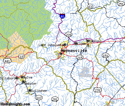
Surrounding areas: Lake Junaluska, North Carolina (3.0 mi), Maggie Valley, North Carolina (5.0 mi), Clyde, North Carolina (5.4 mi), Cruso, North Carolina (11.2 mi), Sylva, North Carolina (15.5 mi), Cullowhee, North Carolina (16.1 mi), Dillsboro, North Carolina (17.0 mi)
|

|
Waynesville Vacation Rentals
|

|
|
|
|
|
Waynesville Hotels and Resorts
|
|
|
| | | Hotels & Motels |
| Best Western Smoky Mountain Inn | 130 Shiloh Trl | Waynesville, NC | | (828) 456-4402 | | Econo Lodge | 1202 Russ Ave | Waynesville, NC | | (828) 452-0353 | | Grandview Londge | 809 Valleyview Cir Rd | Waynesville, NC | | (828) 456-5212 | | Super 8 | 79 Liner Cove Rd | Waynesville, NC | | (828) 454-9667 | | Quality Inn | 70 Soco Rd | Maggie Valley, NC | 3.5 mi. | (828) 926-0201 | | Comfort Inn | 848 Soco Rd | Maggie Valley, NC | 4.1 mi. | (828) 926-9106 | | Best Western Mountainbrook Inn | 3811 Soco Rd | Maggie Valley, NC | 4.2 mi. | (828) 926-3962 | | Meadowlark Motel | 2878 Soco Rd | Maggie Valley, NC | 4.2 mi. | (828) 926-1717 | | Microtel Inn & Suites | 3777 Soco Rd | Maggie Valley, NC | 4.2 mi. | (888) 771-7171 | | Ramada LTD | 4048 Soco Rd | Maggie Valley, NC | 4.2 mi. | (828) 926-7800 | | Best Western Mountainbrook Inn | 1021 Soco Rd Hwy 19 | Maggie Valley, NC | 6.5 mi. | (828) 926-3962 | | Maggie Valley Holiday Motel Inc | 851 Seco Rd | Maggie Valley, NC | 6.5 mi. | (828) 926-1186 | | Balsam Mountain Inn | Balsam MTN Inn Rd | Balsam, NC | 6.9 mi. | (704) 456-9498 | | Comfort Inn Of Canton | I-40 At Exit 31 Champion Dr | Canton, NC | 9.1 mi. | (828) 648-4881 | | Econo Lodge Canton | 55 Buckeye CV Rd | Canton, NC | 9.1 mi. | (828) 648-0300 | | Days Inn West | 2551 Smokey Park Hwy | Candler, NC | 13.6 mi. | (828) 667-9321 | | Comfort Inn | Hwy 23/74 | Sylva, NC | 15.5 mi. | (828) 586-3315 | | University Inn | 563 N Country CLB Dr | Cullowhee, NC | 16.1 mi. | (828) 293-5442 | | Best Western River Escape Inn And Suites | 248 Wbi Dr | Dillsboro, NC | 17.0 mi. | (828) 586-6060 | | Mountain Creek Cottages | 162 Dicks CRK Rd | Dillsboro, NC | 17.0 mi. | (704) 586-6042 | | Baymont Inn-Cherokee/Smoky MTNS | 1455 Acquoni Rd | Cherokee, NC | 18.0 mi. | (828) 497-2102 | | Best Western Great Smokies Inn | 1636 Acquoni Rd | Cherokee, NC | 18.0 mi. | (828) 497-2020 | | Comfort Suites | 35 Hwy 441 North | Cherokee, NC | 18.4 mi. | (828) 497-3500 | | Days Inn Smokey Mountain Inn | 660 Painttown Rd | Cherokee, NC | 18.4 mi. | (828) 497-2300 | | Econo Lodge | Us Hwy 19 | Cherokee, NC | 18.4 mi. | (828) 497-4575 | | Fairfield Inn & Suite - Cherokee | 568 Painttown Rd | Cherokee, NC | 18.4 mi. | (828) 497-0400 | | Hampton Inn | 185 Tsalagi Rd | Cherokee, NC | 18.4 mi. | (828) 497-3115 | | Holiday Inn Cherokee | Hwy 19 W | Cherokee, NC | 18.4 mi. | (828) 497-9181 | | Holiday Inn Expres Hotel & Suites | 376 Paint Town Rd | Cherokee, NC | 18.4 mi. | (828) 497-3113 | | Holiday Inn | Hwy 19 S | Cherokee, NC | 18.4 mi. | (828) 497-9181 | | Microtel Inn & Suites | 674 Casino Trl | Cherokee, NC | 18.4 mi. | (828) 497-7800 | | Quality Inn-cherokee | US 441 N Byp | Cherokee, NC | 18.4 mi. | (828) 497-4702 | | Ramada Limited | 196 Painttown Rd | Cherokee, NC | 18.4 mi. | (828) 497-4231 | | Sleep Inn | Hwy 441 Pob 1956 | Cherokee, NC | 18.4 mi. | (828) 497-4730 | | Travelodge | Acquoni Rd | Cherokee, NC | 18.4 mi. | (828) 497-2226 | | Ramada Plaza Hotel-west | 435 Smokey Park Hwy | Asheville, NC | 20.1 mi. | (704) 665-2161 | | Red Roof Inn #146 | 16 Crowell Rd | Asheville, NC | 20.3 mi. | (704) 667-9803 | | Comfort Inn West | 15 Crowell Rd | Asheville, NC | 20.4 mi. | (828) 665-6500 | | Super8 West | 8 Crowell Rd | Asheville, NC | 20.4 mi. | (828) 667-8706 | | Best Western Biltmore W | 275 Smokey Park Hwy | Asheville, NC | 20.6 mi. | (828) 667-4501 |
| | | Bed & Breakfast |
| Freeze House Bed And Breakfast | 71 Sylvan Heights | Sylva, NC | 15.5 mi. | (828) 586-8161 |

|
Waynesville Weather & Climate
|

|
|
|
The Southwestern Mountains of North Carolina ranges from 800 feet to over 6,600 feet in elevation and the topography definitely affects the local weather. Expect temperatures to be 10 to 20 degrees cooler on the mountaintops than in the valleys below. Spring is unpredictable, particularly at the higher elevations. Snow may fall in March, but by May, things warm up with daytime highs in the 80s. Summer is warm and humid, but more pleasant at the higher elevations, with frequent afternoon showers and thunderstorms. Winter is generally moderate, but more extreme conditions can occur at the mountain peaks. Large snow amounts and severe low temperatures are rare away from the highest peaks. Ski resorts usually rely on snowmaking equipment to ensure a good base. In general, the climate is not extreme, and supports year round activities.
|
| Month |
High Temp |
Low Temp |
Rainfall |
Ocean Temp |
| January |
47°F |
21°F |
4.62 in. |
- |
| February |
50°F |
24°F |
4.54 in. |
- |
| March |
58°F |
30°F |
5.24 in. |
- |
| April |
65°F |
37°F |
3.84 in. |
- |
| May |
73°F |
46°F |
4.43 in. |
- |
| June |
79°F |
53°F |
4.03 in. |
- |
| July |
82°F |
57°F |
3.59 in. |
- |
| August |
81°F |
56°F |
4.11 in. |
- |
| September |
76°F |
50°F |
3.60 in. |
- |
| October |
67°F |
37°F |
2.92 in. |
- |
| November |
58°F |
29°F |
3.81 in. |
- |
| December |
50°F |
24°F |
4.04 in. |
- |

|
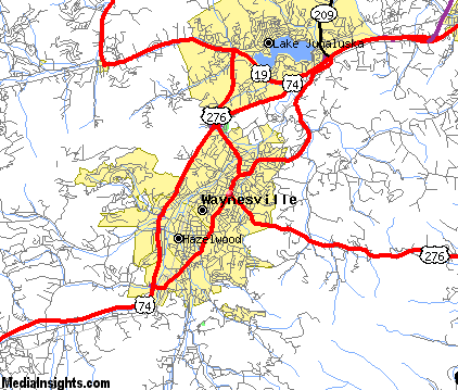
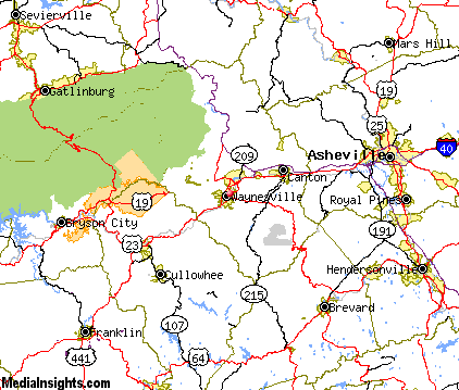
Waynesville Map & Transportation
|

|
|
 |
|
|
| Click each thumbnail image to enlarge. |
 |
|
 |
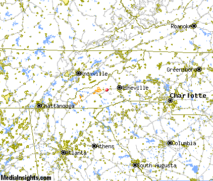 |
The closest airports in the area are the Asheville Regional airport (AVL) located about 25 miles east of Waynesville in Asheville, North Carolina, the Greenville Spartanburg International airport (GSP) located approximately 59 miles southeast of Waynesville in Greer, South Carolina, the Mc Ghee Tyson airport (TYS) located roughly 60 miles northwest of Waynesville in Knoxville, Tennessee, the Donaldson Center airport (GYH) located around 61 miles southeast of Waynesville in Greenville, South Carolina, and finally the Tri Cities Regional Tn Va airport (TRI) located about 75 miles northeast of Waynesville in Bristol Johnson Kingsport, Tennessee.
|

|
Waynesville Attractions
|

|
|
| | | Amusement and Theme Parks |
| Ghost Town in the Sky | Maggie Valley | NC | 6.5 mi. | | | Cherokee Fun Park | Cherokee | NC | 18.4 mi. | | | Santa's Land | Cherokee | NC | 18.4 mi. | | | Dollywood | Pigeon Forge | TN | 37.9 mi. | | | Rockin' Raceway | Pigeon Forge | TN | 37.9 mi. | | | NASCAR SpeedPark | Sevierville | TN | 41.5 mi. | |
| | | Water Parks |
| Lake Lanier Island Beach & Water Park | Lake Lanier Island | GA | 108.2 mi. | |
| | | Golf Courses |
| Lake Junaluska Golf Course | Waynesville | NC | | | | Laurel Ridge Country Club | Waynesville | NC | | | | Smoky Mountain Country Club | Whittier | NC | 21.3 mi. | | | Connestee Falls Golf Course | Brevard | NC | 22.5 mi. | | | Glen Cannon Country Club | Brevard | NC | 22.5 mi. | | | Sherwood Forest Golf Club | Brevard | NC | 22.5 mi. | | | Buncombe County Municipal Golf Course | Asheville | NC | 25.2 mi. | | | Mountain Brook Golf Club | Albemarle | NC | 26.6 mi. | | | Trillium Links & Lake Club | Cashiers | NC | 26.8 mi. | | | High Vista Country Club | Arden | NC | 27.0 mi. | | | Broadmoor Golf Links | Fletcher | NC | 27.8 mi. | | | Reems Creek Golf Course | Weaverville | NC | 27.8 mi. | | | Brookwood Golf Club | Arden | NC | 27.9 mi. | |
| | | Ski Areas |
| Cataloochee | Maggie Valley | NC | 6.5 mi. | | | Ski Wolf Laurel | Mars Hill | NC | 34.0 mi. | | | Scaly Mountain | Scaly Mountain | NC | 37.8 mi. | | | Ski Beech | Banner Elk | NC | 78.0 mi. | | | Sugar Mountain Ski Area | Banner Elk | NC | 78.0 mi. | | | Hawksnest Golf & Ski Resort | Seven Devils | NC | 79.5 mi. | |
| | | State Parks |
| Caesars Head State Park | | SC | 34.3 mi. | | | Table Rock State Park | | SC | 35.6 mi. | | | Keowee Toxaway State Park | | SC | 39.8 mi. | | | Pleasant Ridge State Park | | SC | 39.8 mi. | |
| | | Museums |
| South Carolina Gold Museum | Pickens | SC | 44.7 mi. | (Miscellaneous) | | Bob Jones University Museum & Gallery | Greenville | SC | 55.3 mi. | (Art) |
| | | Zoos and Aquariums |
| Western North Carolina Nature Center | Asheville | NC | 25.6 mi. | | | Greenville Zoo | Greenville | SC | 55.3 mi. | | | Knoxville Zoological Gardens | Knoxville | TN | 61.6 mi. | |
Notice a problem with the information on this page? Please notify us.
|
Disclaimer: We recommend you conduct your own research regarding all accomodations and attractions found on this website. The distances shown on this website are straight-line distances as the crow flies. The road distance may be considerably longer. You assume all liability for use of any information found on this website. No information is confirmed or warranted in any way. By using our services you agree to the terms and conditions of this disclaimer.
|
| We are the #1 site for your North Carolina Vacation presenting North Carolina vacation rentals, hotels, weather and map for each city. |
North Carolina Vacation .com
©1997-2025 All Rights Reserved.
|
|