 |
Cruso
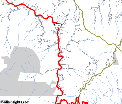
is a small community located in Haywood County on Pisgah Mountain, between the cities of Asheville and Waynesville. According to tradition, the name came from the town's first postmaster after he read the book, "Robinson Cruso." Cruso can be reached via U.S. Highway 276, just four and a half miles from the Blue Ridge Parkway. This mountainous region of western North Carolina is full of historical sites and wonderful attractions. There is a spectacular golf course just two miles north of Cruso on Highway 276, and other activities in the area include hiking, rock climbing, fishing, rafting, horseback riding, mountain biking, camping, downhill and cross country skiing. The region is rich in local arts and crafts, and sightseeing along the mountain highways and byways takes you to many local shops and flea markets. Nearby points of interest include the Biltmore House and Gardens, the Carl Sandburg Home, the Great Smoky Mountain Railway, Great Smoky Mountain National Park, the Pisgah National Forest, Blue Ridge Parkway and the Shining Rock Wilderness Area. The community of Cruso also holds an Annual Community Quilt Show at the Community Center in Canton, featuring handmade quilts, both old and new, made by the ladies of the community.
Surrounding areas: Black Mountain, North Carolina (7.6 mi), Clyde, North Carolina (9.8 mi), Waynesville, North Carolina (11.2 mi), Lake Junaluska, North Carolina (11.4 mi), Pisgah Forest, North Carolina (12.9 mi), Brevard, North Carolina (13.4 mi), Maggie Valley, North Carolina (16.2 mi)
|

|
Cruso Vacation Rentals
|

|
|
|
|
|
Cruso Hotels and Resorts
|
|
|
| | | Hotels & Motels |
| Comfort Inn Of Canton | I-40 At Exit 31 Champion Dr | Canton, NC | 8.1 mi. | (828) 648-4881 | | Econo Lodge Canton | 55 Buckeye CV Rd | Canton, NC | 8.1 mi. | (828) 648-0300 | | Days Inn West | 2551 Smokey Park Hwy | Candler, NC | 9.1 mi. | (828) 667-9321 | | Super 8 | 79 Liner Cove Rd | Waynesville, NC | 10.9 mi. | (828) 454-9667 | | Best Western Smoky Mountain Inn | 130 Shiloh Trl | Waynesville, NC | 11.2 mi. | (828) 456-4402 | | Grandview Londge | 809 Valleyview Cir Rd | Waynesville, NC | 11.2 mi. | (828) 456-5212 | | Econo Lodge | 1202 Russ Ave | Waynesville, NC | 11.6 mi. | (828) 452-0353 | | Holiday Inn Express | 1570 Asheville Hwy | Brevard, NC | 11.7 mi. | (Inv) ali-dInp | | Hampton Inn Brevard | 800 Frst Gate Ctr | Pisgah Forest, NC | 12.9 mi. | (828) 883-4800 | | Brevard Motor Lodge | 750 N Caldwell St | Brevard, NC | 13.2 mi. | (828) 884-3456 | | Imperial Motor Lodge | Hwy 64 & 276 N | Brevard, NC | 13.4 mi. | (828) 884-2887 | | Ramada Plaza Hotel-west | 435 Smokey Park Hwy | Asheville, NC | 13.6 mi. | (704) 665-2161 | | Comfort Suites Biltmore Square Mall | 890 Brevard Rd | Asheville, NC | 13.8 mi. | (704) 665-4000 | | Comfort Inn West | 15 Crowell Rd | Asheville, NC | 13.9 mi. | (828) 665-6500 | | Red Roof Inn #146 | 16 Crowell Rd | Asheville, NC | 13.9 mi. | (704) 667-9803 | | Super8 West | 8 Crowell Rd | Asheville, NC | 14.0 mi. | (828) 667-8706 | | Best Western Biltmore W | 275 Smokey Park Hwy | Asheville, NC | 14.1 mi. | (828) 667-4501 | | Fairfield Inn & Suites | 11 Rocky Ridge Rd | Asheville, NC | 14.1 mi. | (828) 665-4242 | | Hampton Inn | 1 Rocky Ridge Rd | Asheville, NC | 14.1 mi. | (828) 667-2022 | | Holiday Inn Express Hotel & Suites | 1 Wedgefield Dr | Asheville, NC | 14.1 mi. | (828) 665-6519 | | Super 8 Biltmore | 9 Wedgefield Dr | Asheville, NC | 14.1 mi. | (828) 670-8800 | | Sleep Inn | 1918 Old Haywood Rd | Asheville, NC | 14.2 mi. | (828) 670-7600 | | Quality Inn | 70 Soco Rd | Maggie Valley, NC | 14.5 mi. | (828) 926-0201 | | Comfort Inn | 848 Soco Rd | Maggie Valley, NC | 15.3 mi. | (828) 926-9106 | | Best Western Mountainbrook Inn | 3811 Soco Rd | Maggie Valley, NC | 15.4 mi. | (828) 926-3962 | | Meadowlark Motel | 2878 Soco Rd | Maggie Valley, NC | 15.4 mi. | (828) 926-1717 | | Microtel Inn & Suites | 3777 Soco Rd | Maggie Valley, NC | 15.4 mi. | (888) 771-7171 | | Ramada LTD | 4048 Soco Rd | Maggie Valley, NC | 15.4 mi. | (828) 926-7800 | | Balsam Mountain Inn | Balsam MTN Inn Rd | Balsam, NC | 15.5 mi. | (704) 456-9498 | | Comfort Inn-airport | 15 Rockwood Rd | Arden, NC | 15.7 mi. | (828) 687-9199 | | Econo Lodge Airport | 196 Underwood Rd | Fletcher, NC | 15.7 mi. | (704) 684-1200 | | Hampton Inn & Suites | 18 Rockwood Rd | Fletcher, NC | 15.8 mi. | (828) 687-0806 | | Holiday Inn Airport | 550 Airport Rd | Fletcher, NC | 15.8 mi. | (704) 684-1213 | | Days Inn Airport | 183 Underwood Rd | Fletcher, NC | 15.9 mi. | (800) 329-7466 | | Quality Inn & Suites | 1 Skyline Inn Dr | Arden, NC | 16.9 mi. | (828) 684-6688 | | Sun Valley Motel | 2507 Hendersonville Rd | Arden, NC | 17.1 mi. | (828) 684-6944 | | Marriott Execustay/Turtle Creek | 99 Turtle Creek Dr | Asheville, NC | 17.4 mi. | (800) 789-7829 | | Best Western Mountainbrook Inn | 1021 Soco Rd Hwy 19 | Maggie Valley, NC | 17.6 mi. | (828) 926-3962 | | Maggie Valley Holiday Motel Inc | 851 Seco Rd | Maggie Valley, NC | 17.6 mi. | (828) 926-1186 | | Baymont Inn-asheville | 204 Hendersonville Rd | Asheville, NC | 18.2 mi. | (828) 274-2022 |
| | | Bed & Breakfast |
| Woodfield Inn | 2905 Greenville Hwy | Flat Rock, NC | 23.4 mi. | (828) 693-6016 | | Freeze House Bed And Breakfast | 71 Sylvan Heights | Sylva, NC | 23.6 mi. | (828) 586-8161 |

|
Cruso Weather & Climate
|

|
|
|
The Southwestern Mountains of North Carolina ranges from 800 feet to over 6,600 feet in elevation and the topography definitely affects the local weather. Expect temperatures to be 10 to 20 degrees cooler on the mountaintops than in the valleys below. Spring is unpredictable, particularly at the higher elevations. Snow may fall in March, but by May, things warm up with daytime highs in the 80s. Summer is warm and humid, but more pleasant at the higher elevations, with frequent afternoon showers and thunderstorms. Winter is generally moderate, but more extreme conditions can occur at the mountain peaks. Large snow amounts and severe low temperatures are rare away from the highest peaks. Ski resorts usually rely on snowmaking equipment to ensure a good base. In general, the climate is not extreme, and supports year round activities.
|
| Month |
High Temp |
Low Temp |
Rainfall |
Ocean Temp |
| January |
45°F |
23°F |
3.39 in. |
- |
| February |
49°F |
24°F |
3.60 in. |
- |
| March |
57°F |
31°F |
4.50 in. |
- |
| April |
65°F |
38°F |
3.57 in. |
- |
| May |
72°F |
47°F |
4.08 in. |
- |
| June |
78°F |
55°F |
3.02 in. |
- |
| July |
82°F |
60°F |
4.17 in. |
- |
| August |
80°F |
59°F |
3.85 in. |
- |
| September |
75°F |
53°F |
3.19 in. |
- |
| October |
66°F |
40°F |
2.52 in. |
- |
| November |
57°F |
32°F |
3.12 in. |
- |
| December |
49°F |
26°F |
2.96 in. |
- |

|
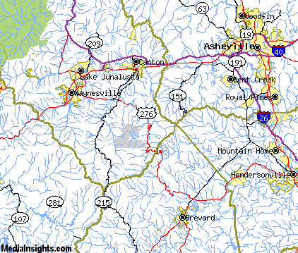
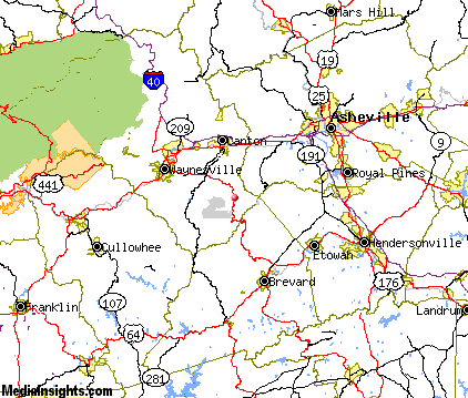
Cruso Map & Transportation
|

|
|
 |
|
|
| Click each thumbnail image to enlarge. |
 |
|
 |
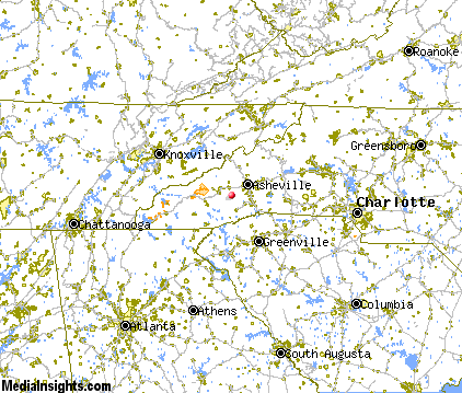 |
The closest airports in the area are the Asheville Regional airport (AVL) located about 15 miles east of Cruso in Asheville, North Carolina, the Greenville Spartanburg International airport (GSP) located approximately 49 miles southeast of Cruso in Greer, South Carolina, the Donaldson Center airport (GYH) located roughly 51 miles south of Cruso in Greenville, South Carolina, and finally the Mc Ghee Tyson airport (TYS) located around 71 miles northwest of Cruso in Knoxville, Tennessee.
|

|
Cruso Attractions
|

|
|
| | | Amusement and Theme Parks |
| Ghost Town in the Sky | Maggie Valley | NC | 17.6 mi. | | | Cherokee Fun Park | Cherokee | NC | 28.6 mi. | | | Santa's Land | Cherokee | NC | 28.6 mi. | | | Dollywood | Pigeon Forge | TN | 49.0 mi. | | | Rockin' Raceway | Pigeon Forge | TN | 49.0 mi. | | | NASCAR SpeedPark | Sevierville | TN | 52.4 mi. | |
| | | Water Parks |
| Lake Lanier Island Beach & Water Park | Lake Lanier Island | GA | 110.2 mi. | | | Paramount's Carowinds-Water Works | Pineville | NC | 110.7 mi. | |
| | | Golf Courses |
| Lake Junaluska Golf Course | Waynesville | NC | 10.5 mi. | | | Laurel Ridge Country Club | Waynesville | NC | 10.5 mi. | | | Connestee Falls Golf Course | Brevard | NC | 13.0 mi. | | | Glen Cannon Country Club | Brevard | NC | 13.0 mi. | | | Sherwood Forest Golf Club | Brevard | NC | 13.0 mi. | | | High Vista Country Club | Arden | NC | 17.2 mi. | | | Broadmoor Golf Links | Fletcher | NC | 17.5 mi. | | | Buncombe County Municipal Golf Course | Asheville | NC | 18.2 mi. | | | Brookwood Golf Club | Arden | NC | 18.5 mi. | | | Mountain Brook Golf Club | Albemarle | NC | 20.2 mi. | | | Crooked Creek Golf Club | Hendersonville | NC | 20.8 mi. | | | Cummings Cove Golf & Country Club | Hendersonville | NC | 20.8 mi. | | | Orchard Trace Golf Club | Hendersonville | NC | 20.8 mi. | | | Reems Creek Golf Course | Weaverville | NC | 23.5 mi. | | | Willow Springs Country Club | Wilson | NC | 25.0 mi. | | | Trillium Links & Lake Club | Cashiers | NC | 26.7 mi. | |
| | | Ski Areas |
| Cataloochee | Maggie Valley | NC | 17.6 mi. | | | Ski Wolf Laurel | Mars Hill | NC | 31.8 mi. | | | Scaly Mountain | Scaly Mountain | NC | 40.0 mi. | | | Ski Beech | Banner Elk | NC | 73.7 mi. | | | Sugar Mountain Ski Area | Banner Elk | NC | 73.7 mi. | | | Hawksnest Golf & Ski Resort | Seven Devils | NC | 74.9 mi. | |
| | | State Parks |
| Caesars Head State Park | | SC | 24.7 mi. | | | Table Rock State Park | | SC | 27.5 mi. | | | Pleasant Ridge State Park | | SC | 29.3 mi. | | | Keowee Toxaway State Park | | SC | 34.6 mi. | | | Mount Mitchell State Park | | NC | 39.4 mi. | |
| | | Museums |
| South Carolina Gold Museum | Pickens | SC | 37.4 mi. | (Miscellaneous) | | Bob Jones University Museum & Gallery | Greenville | SC | 45.6 mi. | (Art) |
| | | Zoos and Aquariums |
| Western North Carolina Nature Center | Asheville | NC | 19.2 mi. | | | Greenville Zoo | Greenville | SC | 45.6 mi. | | | Knoxville Zoological Gardens | Knoxville | TN | 72.7 mi. | |
Notice a problem with the information on this page? Please notify us.
|
Disclaimer: We recommend you conduct your own research regarding all accomodations and attractions found on this website. The distances shown on this website are straight-line distances as the crow flies. The road distance may be considerably longer. You assume all liability for use of any information found on this website. No information is confirmed or warranted in any way. By using our services you agree to the terms and conditions of this disclaimer.
|
| We are the #1 site for your North Carolina Vacation presenting North Carolina vacation rentals, hotels, weather and map for each city. |
North Carolina Vacation .com
©1997-2025 All Rights Reserved.
|
|