 |
Clyde
is a small town located on the banks of the Pigeon River near the Pisgah National Forest and the Great Smoky Mountains National Park. It is known as a place to really "get away from it all," with a low cost of living and an even lower crime rate. The town lies in the midst of some of the country's most gorgeous mountain scenery, with easy access to I-40 and the town of Asheville just 40 minutes away. Clyde is near several golf courses, hiking trails, horseback riding, whitewater rafting, and superb trout and bass fishing. Nearby Maggie Valley is home to the Cataloochee Ski Slopes, and many public and private campgrounds can be found in the forested mountains surrounding Clyde. Other nearby attractions include the popular Smoky Mountains and the towns of Gatlinburg and Pigeon Forge, Dollywood, Cades Cove, the Cherokee Indian Reservation, Blue Ridge Parkway and Biltmore House Estate in Asheville. If you are looking for a place with gorgeous mountain views, a peaceful, small town atmosphere and friendly people - a place that isn't too isolated from all of the national parks' attractions and outdoor recreation - the town of Clyde makes the perfect base for your next North Carolina vacation.
Surrounding areas: Lake Junaluska, North Carolina (3.0 mi), Waynesville, North Carolina (5.4 mi), Maggie Valley, North Carolina (9.2 mi), Cruso, North Carolina (9.8 mi), Black Mountain, North Carolina (17.4 mi), Asheville, North Carolina (20.6 mi), Sylva, North Carolina (20.9 mi)
|

|
Clyde Vacation Rentals
|

|
|
|
|
|
Clyde Hotels and Resorts
|
|
|
| | | Hotels & Motels |
| Super 8 | 79 Liner Cove Rd | Waynesville, NC | 2.7 mi. | (828) 454-9667 | | Comfort Inn Of Canton | I-40 At Exit 31 Champion Dr | Canton, NC | 4.1 mi. | (828) 648-4881 | | Econo Lodge Canton | 55 Buckeye CV Rd | Canton, NC | 4.1 mi. | (828) 648-0300 | | Econo Lodge | 1202 Russ Ave | Waynesville, NC | 4.9 mi. | (828) 452-0353 | | Best Western Smoky Mountain Inn | 130 Shiloh Trl | Waynesville, NC | 5.4 mi. | (828) 456-4402 | | Grandview Londge | 809 Valleyview Cir Rd | Waynesville, NC | 5.4 mi. | (828) 456-5212 | | Quality Inn | 70 Soco Rd | Maggie Valley, NC | 7.1 mi. | (828) 926-0201 | | Comfort Inn | 848 Soco Rd | Maggie Valley, NC | 8.0 mi. | (828) 926-9106 | | Best Western Mountainbrook Inn | 3811 Soco Rd | Maggie Valley, NC | 8.2 mi. | (828) 926-3962 | | Meadowlark Motel | 2878 Soco Rd | Maggie Valley, NC | 8.2 mi. | (828) 926-1717 | | Microtel Inn & Suites | 3777 Soco Rd | Maggie Valley, NC | 8.2 mi. | (888) 771-7171 | | Ramada LTD | 4048 Soco Rd | Maggie Valley, NC | 8.2 mi. | (828) 926-7800 | | Days Inn West | 2551 Smokey Park Hwy | Candler, NC | 8.8 mi. | (828) 667-9321 | | Best Western Mountainbrook Inn | 1021 Soco Rd Hwy 19 | Maggie Valley, NC | 10.6 mi. | (828) 926-3962 | | Maggie Valley Holiday Motel Inc | 851 Seco Rd | Maggie Valley, NC | 10.6 mi. | (828) 926-1186 | | Balsam Mountain Inn | Balsam MTN Inn Rd | Balsam, NC | 12.3 mi. | (704) 456-9498 | | Ramada Plaza Hotel-west | 435 Smokey Park Hwy | Asheville, NC | 15.3 mi. | (704) 665-2161 | | Red Roof Inn #146 | 16 Crowell Rd | Asheville, NC | 15.4 mi. | (704) 667-9803 | | Comfort Inn West | 15 Crowell Rd | Asheville, NC | 15.5 mi. | (828) 665-6500 | | Super8 West | 8 Crowell Rd | Asheville, NC | 15.5 mi. | (828) 667-8706 | | Sleep Inn | 1918 Old Haywood Rd | Asheville, NC | 15.7 mi. | (828) 670-7600 | | Best Western Biltmore W | 275 Smokey Park Hwy | Asheville, NC | 15.8 mi. | (828) 667-4501 | | Comfort Suites Biltmore Square Mall | 890 Brevard Rd | Asheville, NC | 17.1 mi. | (704) 665-4000 | | Fairfield Inn & Suites | 11 Rocky Ridge Rd | Asheville, NC | 17.1 mi. | (828) 665-4242 | | Hampton Inn | 1 Rocky Ridge Rd | Asheville, NC | 17.2 mi. | (828) 667-2022 | | Super 8 Biltmore | 9 Wedgefield Dr | Asheville, NC | 17.2 mi. | (828) 670-8800 | | Holiday Inn Express Hotel & Suites | 1 Wedgefield Dr | Asheville, NC | 17.3 mi. | (828) 665-6519 | | Courtyard By Marriott | One Buckstone Pl | Asheville, NC | 20.6 mi. | (828) 281-0041 | | Days Inn E | 1500 Tunl Rd | Asheville, NC | 20.6 mi. | (828) 298-5140 | | Days Inn-asheville Mall | 201 Tunl Rd | Asheville, NC | 20.6 mi. | (828) 252-4000 | | Econo Lodge Asheville | 190 Tunl Rd | Asheville, NC | 20.6 mi. | (828) 254-9521 | | Econo Lodge East | I-40 Exit 55 | Asheville, NC | 20.6 mi. | (828) 298-5519 | | Econo Lodge | I-85 And Bessemer City Rd | Asheville, NC | 20.6 mi. | (704) 867-1821 | | Fairfield Inn By Marriott Asheville | 31 Airport Park Dr | Asheville, NC | 20.6 mi. | (704) 684-1144 | | Motel 6 Asheville | 1415 Tunl Rd | Asheville, NC | 20.6 mi. | (828) 299-3040 | | Ramada Limited | 180 Tunl Rd | Asheville, NC | 20.6 mi. | (828) 254-7451 | | Renaissance By Marriott Asheville | One Thomas Wolfe Plaza | Asheville, NC | 20.6 mi. | (800) 845-5279 | | Super 8 E | 1329 Tunl Rd | Asheville, NC | 20.6 mi. | (828) 298-7952 | | American Court Motel | 85 Merrimon Ave | Asheville, NC | 20.7 mi. | (828) 253-4427 | | Residence Inn | 701 Biltmore Ave | Asheville, NC | 20.7 mi. | (828) 281-3361 |
| | | Bed & Breakfast |
| Freeze House Bed And Breakfast | 71 Sylvan Heights | Sylva, NC | 20.9 mi. | (828) 586-8161 | | Baird House LTD Bed And Breakfast Inn | 41 S Main St | Mars Hill, NC | 28.6 mi. | (828) 689-5722 |

|
Clyde Weather & Climate
|

|
|
|
The weather in Asheville and the surrounding areas is hard to predict. The city of Asheville sits in a valley at about 2,200 feet and is surrounded by mountains of more than 6,000 feet in elevation. Temperatures usually run 10 to 25 degrees cooler in the higher elevations than in the city. Spring has mild days and cool nights with some rainy days. Summer is warm and humid with scattered afternoon thunderstorms. Temperatures rarely rise above 90 degrees in this region (or above 80 at elevations of 5,000 feet or higher.) Conditions cool down a little by October, and that is also the best month to view the spectacular fall foliage. In winter, the high mountains protect the city and outlying areas, so there is seldom a major snowfall. Highs run in the 40s and 50s.
|
| Month |
High Temp |
Low Temp |
Rainfall |
Ocean Temp |
| January |
45°F |
23°F |
3.39 in. |
- |
| February |
49°F |
24°F |
3.60 in. |
- |
| March |
57°F |
31°F |
4.50 in. |
- |
| April |
65°F |
38°F |
3.57 in. |
- |
| May |
72°F |
47°F |
4.08 in. |
- |
| June |
78°F |
55°F |
3.02 in. |
- |
| July |
82°F |
60°F |
4.17 in. |
- |
| August |
80°F |
59°F |
3.85 in. |
- |
| September |
75°F |
53°F |
3.19 in. |
- |
| October |
66°F |
40°F |
2.52 in. |
- |
| November |
57°F |
32°F |
3.12 in. |
- |
| December |
49°F |
26°F |
2.96 in. |
- |

|
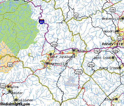
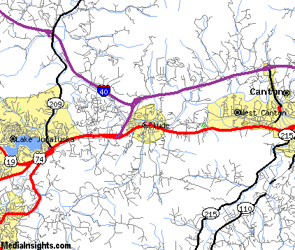
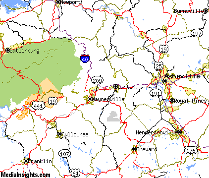
Clyde Map & Transportation
|

|
|
 |
|
|
| Click each thumbnail image to enlarge. |
 |
|
 |
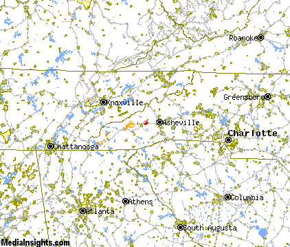 |
The closest airports in the area are the Asheville Regional airport (AVL) located about 21 miles southeast of Clyde in Asheville, North Carolina, the Greenville Spartanburg International airport (GSP) located approximately 58 miles southeast of Clyde in Greer, South Carolina, the Donaldson Center airport (GYH) located roughly 61 miles south of Clyde in Greenville, South Carolina, the Mc Ghee Tyson airport (TYS) located around 63 miles southeast of Clyde in Knoxville, Tennessee, and finally the Tri Cities Regional Tn Va airport (TRI) located about 70 miles northeast of Clyde in Bristol Johnson Kingsport, Tennessee.
|

|
Clyde Attractions
|

|
|
| | | Amusement and Theme Parks |
| Ghost Town in the Sky | Maggie Valley | NC | 10.6 mi. | | | Cherokee Fun Park | Cherokee | NC | 23.1 mi. | | | Santa's Land | Cherokee | NC | 23.1 mi. | | | Dollywood | Pigeon Forge | TN | 40.2 mi. | | | Rockin' Raceway | Pigeon Forge | TN | 40.2 mi. | | | NASCAR SpeedPark | Sevierville | TN | 43.2 mi. | |
| | | Water Parks |
| Lake Lanier Island Beach & Water Park | Lake Lanier Island | GA | 113.2 mi. | | | Paramount's Carowinds-Water Works | Pineville | NC | 118.0 mi. | |
| | | Golf Courses |
| Lake Junaluska Golf Course | Waynesville | NC | 5.4 mi. | | | Laurel Ridge Country Club | Waynesville | NC | 5.4 mi. | | | Buncombe County Municipal Golf Course | Asheville | NC | 20.2 mi. | | | Mountain Brook Golf Club | Albemarle | NC | 21.5 mi. | | | Reems Creek Golf Course | Weaverville | NC | 22.5 mi. | | | Connestee Falls Golf Course | Brevard | NC | 22.6 mi. | | | Glen Cannon Country Club | Brevard | NC | 22.6 mi. | | | Sherwood Forest Golf Club | Brevard | NC | 22.6 mi. | | | High Vista Country Club | Arden | NC | 23.1 mi. | | | Brookwood Golf Club | Arden | NC | 23.8 mi. | | | Broadmoor Golf Links | Fletcher | NC | 24.2 mi. | | | Smoky Mountain Country Club | Whittier | NC | 26.3 mi. | | | Willow Springs Country Club | Wilson | NC | 27.9 mi. | | | Crooked Creek Golf Club | Hendersonville | NC | 29.3 mi. | | | Cummings Cove Golf & Country Club | Hendersonville | NC | 29.3 mi. | | | Orchard Trace Golf Club | Hendersonville | NC | 29.3 mi. | |
| | | Ski Areas |
| Cataloochee | Maggie Valley | NC | 10.6 mi. | | | Ski Wolf Laurel | Mars Hill | NC | 28.7 mi. | | | Scaly Mountain | Scaly Mountain | NC | 42.7 mi. | | | Ski Beech | Banner Elk | NC | 72.7 mi. | | | Sugar Mountain Ski Area | Banner Elk | NC | 72.7 mi. | | | Hawksnest Golf & Ski Resort | Seven Devils | NC | 74.1 mi. | |
| | | State Parks |
| Caesars Head State Park | | SC | 34.4 mi. | | | Table Rock State Park | | SC | 36.8 mi. | | | Pleasant Ridge State Park | | SC | 39.1 mi. | |
| | | Museums |
| South Carolina Gold Museum | Pickens | SC | 46.4 mi. | (Miscellaneous) | | Bob Jones University Museum & Gallery | Greenville | SC | 55.4 mi. | (Art) |
| | | Zoos and Aquariums |
| Western North Carolina Nature Center | Asheville | NC | 20.6 mi. | | | Greenville Zoo | Greenville | SC | 55.4 mi. | | | Knoxville Zoological Gardens | Knoxville | TN | 63.9 mi. | |
Notice a problem with the information on this page? Please notify us.
|
Disclaimer: We recommend you conduct your own research regarding all accomodations and attractions found on this website. The distances shown on this website are straight-line distances as the crow flies. The road distance may be considerably longer. You assume all liability for use of any information found on this website. No information is confirmed or warranted in any way. By using our services you agree to the terms and conditions of this disclaimer.
|
| We are the #1 site for your North Carolina Vacation presenting North Carolina vacation rentals, hotels, weather and map for each city. |
North Carolina Vacation .com
©1997-2025 All Rights Reserved.
|
|