 |
Spruce-Pine
is a pretty town located in Mitchell County, northeast of the city of Asheville and just a few miles from the Blue Ridge Parkway. It lies on the banks of the North Toe River near famous attractions like Linville Falls and Linville Gorge, Grandfather Mountain and the Pisgah National Forest. Recreation opportunities abound near Spruce Pine including whitewater rafting, canoeing, hiking, backpacking, mountain biking, rock climbing, fishing and hunting. Linville Gorge includes 39 miles of trails; much of it considered a primitive area, but there is an easy-to-moderate trail that leads to the falls. A short drive north of Spruce Pine takes you to Roan Mountain, home to the largest, naturally occurring rhododendron gardens in the world and the site of the North Carolina Rhododendron Festival each June. Rockhounds also flock to this area, which is known for its' rich deposits of gemstones and minerals. Grandfather Mountain, just northeast of Spruce Pine is the highest peak and one of the oldest in the Blue Ridge Mountains. Visitors can drive to the crest of the mountain and walk across the mountain's famous "Mile High Swinging Bridge." Other attractions near Spruce Pine include skiing at Sugar Mountain and the quaint resort towns of Banner Elk and Blowing Rock.
Surrounding areas: Little Switzerland, North Carolina (4.8 mi), Plumtree, North Carolina (8.3 mi), Celo, North Carolina (8.5 mi), Bakersville, North Carolina (8.7 mi), Linville, North Carolina (12.8 mi), Green Mountain, North Carolina (13.6 mi), Newland, North Carolina (14.1 mi)
|

|
Spruce Pine Vacation Rentals
|

|
|
|
|
|
Spruce Pine Hotels and Resorts
|
|
|
| | | Hotels & Motels |
| Big Lynn Lodge | | Little Switzrlnd, NC | 4.6 mi. | (704) 765-4257 | | Eseeola Lodge | 175 Linville Ave | Linville, NC | 15.1 mi. | (828) 733-4311 | | Pixie Inn | US 221 | Linville, NC | 15.1 mi. | (704) 733-2597 | | Pixie Inn | | Linville, NC | 15.1 mi. | (704) 733-2597 | | Comfort Inn | 178 Hwy 70 W | Marion, NC | 16.3 mi. | (828) 652-4888 | | Days Inn | 4248 Hwy 221 S | Marion, NC | 16.3 mi. | (828) 659-2567 | | Econo Lodge | Rt 1 Box 68a | Marion, NC | 16.3 mi. | (828) 659-7940 | | Sugar Mountain Ski And Country Club | | Banner Elk, NC | 20.2 mi. | (828) 898-9784 | | Assembly Inn | | Montreat, NC | 23.0 mi. | (828) 669-2911 | | Sleep Inn Morganton | 2400a S Sterling St | Morganton, NC | 24.3 mi. | (828) 433-9000 | | Comfort Inn & Suites | 1273 Burkemont Ave | Morganton, NC | 24.8 mi. | (828) 669-2922 | | Comfort Inn | 585 Hwy 9 I-40 Exit 64 | Black Mountain, NC | 25.1 mi. | (828) 669-9950 | | Holiday Inn Express | 2002 Temple HL Rd | Erwin, TN | 25.3 mi. | (423) 743-4100 | | Alpen Acres | 156 Old US Hwy 321 S | Blowing Rock, NC | 26.4 mi. | (828) 295-7981 | | Chetola Resort & Conference Center | | Blowing Rock, NC | 26.4 mi. | (800) 243-8652 | | Chetola Resort & Conference | | Blowing Rock, NC | 26.4 mi. | (828) 295-5500 | | Days Inn Blowing Rock | Hwy 321 Byp | Blowing Rock, NC | 26.4 mi. | (828) 295-4422 | | Ridgeway Motor Inn | Hwy 221 | Blowing Rock, NC | 26.4 mi. | (828) 295-7321 | | Days Inn Morganton | 2402 S Sterling St | Morganton, NC | 26.4 mi. | (828) 433-0011 | | Hampton Inn Morganton | 115 Bush Dr | Morganton, NC | 26.4 mi. | (828) 432-2000 | | Holiday Inn Morganton | 2400 S Sterling St | Morganton, NC | 26.4 mi. | (828) 437-0171 | | Comfort Inn | 167 J F Robinson Ln | Mars Hill, NC | 27.8 mi. | (828) 689-9000 | | R & R Hideaway | Hwy 18 Wilksboro Blvd | Lenoir, NC | 29.4 mi. | (828) 754-5600 | | Quality Inn Appalachian Conference CTR | 949 Blowing Rock Rd | Boone, NC | 29.8 mi. | (828) 262-0020 |
| | | Bed & Breakfast |
| Baird House LTD Bed And Breakfast Inn | 41 S Main St | Mars Hill, NC | 27.8 mi. | (828) 689-5722 |

|
Spruce Pine Weather & Climate
|

|
|
|
North Carolina has the greatest range of altitude of any state east of the Mississippi River, ranging from sea level along the Atlantic coast to 6,684 feet at the summit of Mt. Mitchell in the heart of the Blue Ridge Mountains. Latitude accounts for climatic variations, as does soils, plant cover and inland bodies of water. There is no distinct wet or dry season in North Carolina. Average snowfall in the southern mountains is around 16 inches, with some of the higher mountain peaks and upper slopes receiving as much as 50 inches per year. July is usually the wettest month. Summer rainfall is the most variable; daily showers are not uncommon, but periods of one to two weeks without rain are also normal. Autumn is the driest season, and also sees the greatest drop-off of temperature in the month of October.
|
| Month |
High Temp |
Low Temp |
Rainfall |
Ocean Temp |
| January |
46°F |
21°F |
5.58 in. |
- |
| February |
49°F |
23°F |
5.07 in. |
- |
| March |
57°F |
30°F |
6.30 in. |
- |
| April |
65°F |
37°F |
4.60 in. |
- |
| May |
72°F |
45°F |
5.32 in. |
- |
| June |
78°F |
53°F |
4.54 in. |
- |
| July |
82°F |
57°F |
4.43 in. |
- |
| August |
81°F |
56°F |
5.02 in. |
- |
| September |
76°F |
50°F |
4.55 in. |
- |
| October |
68°F |
37°F |
4.18 in. |
- |
| November |
59°F |
30°F |
5.05 in. |
- |
| December |
50°F |
24°F |
4.19 in. |
- |

|
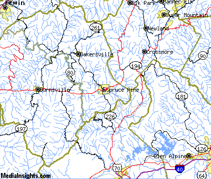
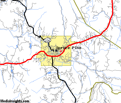
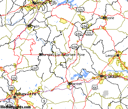
Spruce Pine Map & Transportation
|

|
|
 |
|
|
| Click each thumbnail image to enlarge. |
 |
|
 |
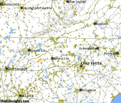 |
The closest airports in the area are the Asheville Regional airport (AVL) located about 42 miles southwest of Spruce Pine in Asheville, North Carolina, the Tri Cities Regional Tn Va airport (TRI) located approximately 43 miles northwest of Spruce Pine in Bristol Johnson Kingsport, Tennessee, the Shelby Municipal airport (EHO) located roughly 52 miles south of Spruce Pine in Shelby, North Carolina, and finally the Greenville Spartanburg International airport (GSP) located around 70 miles south of Spruce Pine in Greer, South Carolina.
|

|
Spruce Pine Attractions
|

|
|
| | | Amusement and Theme Parks |
| Ghost Town in the Sky | Maggie Valley | NC | 64.1 mi. | | | Cherokee Fun Park | Cherokee | NC | 76.5 mi. | | | Santa's Land | Cherokee | NC | 76.5 mi. | | | Paramount's Carowinds | Charlotte | NC | 83.5 mi. | | | Dollywood | Pigeon Forge | TN | 83.9 mi. | | | Rockin' Raceway | Pigeon Forge | TN | 83.9 mi. | | | NASCAR SpeedPark | Sevierville | TN | 83.9 mi. | |
| | | Water Parks |
| Paramount's Carowinds-Water Works | Pineville | NC | 87.5 mi. | |
| | | Golf Courses |
| Grassy Creek Golf & Country Club | Spruce Pine | NC | | | | Mount Mitchell Golf Club | Burnsville | NC | 13.0 mi. | | | Mountain Glen Golf Course | Newland | NC | 14.1 mi. | | | Green Oaks Golf Club | Concord | NC | 14.6 mi. | | | Rocky River Golf Club at Concord | Concord | NC | 14.6 mi. | | | Village of Sugar Mountain Golf Course | Banner Elk | NC | 20.0 mi. | | | Hawksnest Golf & Ski Resort | Seven Devils | NC | 20.9 mi. | | | Old Fort Golf Course | Old Fort | NC | 21.4 mi. | | | Quaker Meadows Golf Club | Morganton | NC | 22.5 mi. | | | Buffalo Valley Golf Course | Unicoi | TN | 24.4 mi. | | | Silver Creek Plantation | Morganton | NC | 24.7 mi. | | | Magnolia Golf Club | Magnolia | NC | 25.0 mi. | | | Black Mountain Golf Course | Black Mountain | NC | 25.5 mi. | | | Tillery Tradition Country Club | Mount Gilead | NC | 25.5 mi. | | | Country Acres Golf Club | Lenoir | NC | 29.9 mi. | | | Lenoir Golf Course | Lenoir | NC | 29.9 mi. | |
| | | Ski Areas |
| Ski Beech | Banner Elk | NC | 20.2 mi. | | | Sugar Mountain Ski Area | Banner Elk | NC | 20.2 mi. | | | Hawksnest Golf & Ski Resort | Seven Devils | NC | 21.1 mi. | | | Ski Wolf Laurel | Mars Hill | NC | 27.8 mi. | | | Cataloochee | Maggie Valley | NC | 64.1 mi. | | | Scaly Mountain | Scaly Mountain | NC | 94.1 mi. | |
| | | State Parks |
| Mount Mitchell State Park | | NC | 14.9 mi. | |
| | | Museums |
| Carroll Reece Museum | Johnson City | TN | 31.9 mi. | (Multidisciplinary) | | Hands On! Regional Museum | Johnson City | TN | 31.9 mi. | (Children's) | | Hickory Museum of Art | Hickory | NC | 42.4 mi. | (Art) |
| | | Zoos and Aquariums |
| Western North Carolina Nature Center | Asheville | NC | 35.0 mi. | | | Greenville Zoo | Greenville | SC | 75.8 mi. | | | Knoxville Zoological Gardens | Knoxville | TN | 103.9 mi. | |
Notice a problem with the information on this page? Please notify us.
|
Disclaimer: We recommend you conduct your own research regarding all accomodations and attractions found on this website. The distances shown on this website are straight-line distances as the crow flies. The road distance may be considerably longer. You assume all liability for use of any information found on this website. No information is confirmed or warranted in any way. By using our services you agree to the terms and conditions of this disclaimer.
|
| We are the #1 site for your North Carolina Vacation presenting North Carolina vacation rentals, hotels, weather and map for each city. |
North Carolina Vacation .com
©1997-2025 All Rights Reserved.
|
|